Sea Level
TUVALU
(lat. 8.0S, long. 178.0E)
This page presents graphs of sea level at Funafuti (or Fongafale), one of the major islands of the group. The data used here is the monthly values of the 1985-2001 Revised Local Reference data from the Proudman Oceanographic Laboratory (see here), where the Funafuti dataset has reference number 732/011. (The data prior to 1985 has gaps in it and has been rejected.)
These graphs show that high seas in March are a normal occurrence and that the local sea level falls under the influence of strong El Nino conditions then rises when those conditions disappear.
There is no evidence of permanently rising seas that can be matched to the supposed increase in average global temperature since 1976.
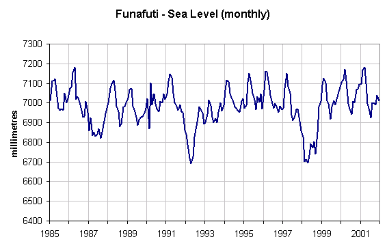
Fig 1 - Monthly sea level data
Notes:
1 - The year labels on this graph correspond to January of that year
2 - The reference level is arbitrarily set about 7000mm below normal sea level in order to avoid negative heights, so
the variation in values is more important than the numeric data.
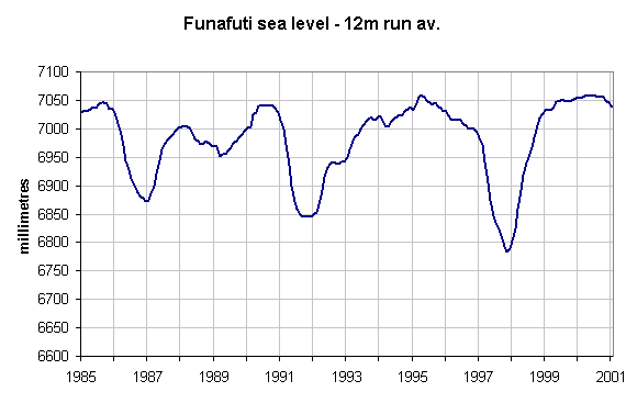
Fig 2 - Running 12-month averages.
Notes:
1 - The data shown is the average of
that current month and 11 previous months.
2 - The year label corresponds to December of that year, and is therefore the annual average.
3 - There is no indication that the sea level is rising but across this period the low points in sea level show
a pattern of decreases.
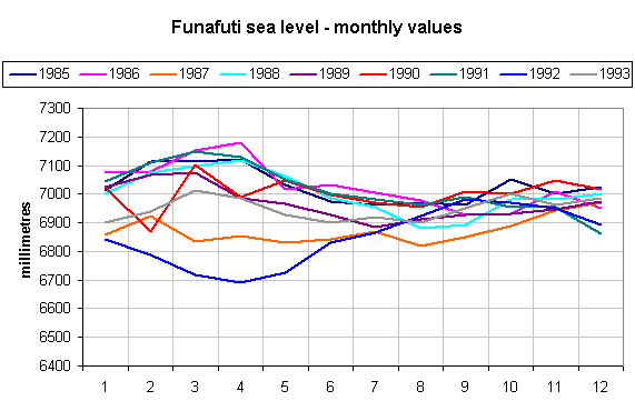
Fig 3 - Sea-level across the calendar year(1) - see also below
Notes:
1 - A rise in sea-level about March-April is
quite normal except when strong El Nino conditions occur in the months
leading up to this time of the year (see table
below)
2 - There is no obvious reason for the abrupt fall in sea level during February
and April 1990 but in each case by the next month
the situation seems to be back to normal.
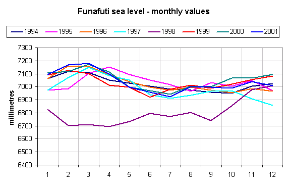
Fig 4 - Sea-level across the calendar year (2) - see also above
Notes:
1 - The low sea level of 1998 can be directly attributed
to the strong El Nino which started during the previous year (see the table
above).