Sea Level at Kakadu
The park has about 100km of coastline fronting Van Diemen Gulf, which is basically a large bay with narrow entrances to the north (Dundas Strait) and the west (Clarence Strait). The East Alligator River and the South Alligator River, along with the smaller West Alligator River and Wildman River drain fresh water from the park into the Gulf.
It is claimed that the natural levees near the mouths of these rivers are as little as 20cm above water level and could easily be breached by rising sea level, which would cause salt water intrusion into fresh water systems.
What was done: Data for the two nearest monitoring stations, Darwin and Milner Bay (Groote Eylandt), was obtained from the Proudman Oceanographic Laboratory (POL) and the Revised Local Reference data (see POL) was consistently adjusted (by subtracting 7000mm) to present it as an anomaly from the monitoring station baselines. (The only reason for doing this was to indicate a variation from 0 rather than show data values somewhere near 7000.) The 12-month running average (current month and 11 previous) was calculated and this was graphed with the 12-month running average of the Southern Oscillation Index (SOI), a measure of the El Nino Southern Oscillation (ENSO).
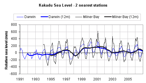
Fig 1 - Monthly sea level and 12-month running averages for Darwin and Milner Bay
What was found: Sea level at Darwin and Milner Bay has a
regular cycle of higher sea in summer (Dec-Feb) and lower sea in winter (June-August). For these two locations sea level varies
synchronously and in accordance with the state of the ENSO system, rising as the SOI moves in a positive direction (i.e. towards
La Nina) and falling as the SOI moves in a negative direction (towards El Nino). Van Diemen Gulf may have relatively small
entrances but it is virtually certain that sea level along the coastline of Kakadu National Park rises and falls in the same
manner.
It therefore follows that sea level at previous times of strong La Nina conditions might have topped the natural
levees of the freshwater rivers especially if the La Nina conditions existed across the summer period of high seas. These two
conditions were met across 1975-6 with the month average SOI values of 19.5, 11.8 and 12.9 from December 1975 to February 1976,
so the levees may have been breached on that occasion. In the archive of SOI values we find 13 other December-February periods
of positive SOI values and similar breaches may have occurred at that time.
It is also noted that sea level at Darwin
since 1998 is lower than the general relationship with the SOI suggests. (If the line for SOI is raised to match the line for
sea level in the pre-1997 period then after 1997 the line for SOI will be above the line for sea level.) The reasons for this
are not clear but it does suggest that sea level is rising less than might be expected. The 12-month running average of sea
level at Darwin matches that at Milner Bay quite well so it seems unlikely that there was a sudden change in the height of
the tidal guage.
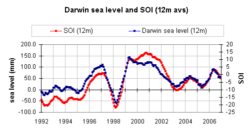
Fig 2 - 12-month running averages for Darwin and for the Southern Oscillation Index.