Rainfall in the Murray-Darling Basin
| (Observational data used on this web page is available from the Australian Bureau of Meteorology at this page.) | ||||||||||||||||||||
Introduction |
||||||||||||||||||||
|
We are often told that rainfall is decreasing in the
Murray-Darling Basin ... and that the rivers will soon dry up
...and there will be no water for irrigation ... and it will all
be a dustbowl (etc. etc.) Let's take a look at the real situation according to Bureau of Meteorology data. |
||||||||||||||||||||
Heres a graph of rainfall as taken directly from the Bureau of Meteorology web page mentioned above
and with some average rainfall lines added to it.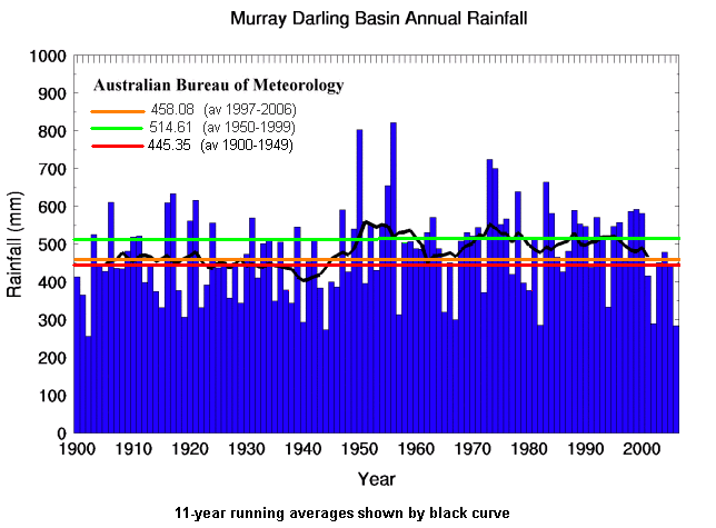 By gosh it looks like the 50-year period from 1900 to 1949 was rather dry! The average over that 50 year period is even lower than the average from 1997 to 2006. |
||||||||||||||||||||
|
||||||||||||||||||||
|
The lowest average rainfall over a 10-year period was from 1937 to 1946 (397.5mm),
the average rainfall over 10 years is 481.6mm - or on imperial scale that farmers often still use, 3.5 inches
more than that lowest value. The highest average over 10 years was from 1947 to 1956 (576.8mm). In context, the
average rainfall from 1997 to 2006 was 458.08mm, the 30th lowest of 91
values. The 5-year averages tell a different story with the lowest being 1940 to 1944 (383.8mm), 2002 to 2006 being second lowest (390.0mm), the average 479.7mm and the maximum being from 1952 to 1956 (602.3mm). Years 2002 and 2006 had two of the lowest 5 annual total rainfalls since (and including) 1900 but on the other hand the years 1998, 1999 and 2000 are 3 of the 15 highest annual totals since 1900 (and 3 of the 5 highest since 1980). Rainfall during winter and spring can be linked to the state of the Southern Oscillation. (This is not merely my opinion but a view held by the Bureau of Meteorology last time I looked.) The figure below shows a scattergram of the average value of the Southern Oscillation Index (SOI) from May to November (i.e. winter & spring), along with the variation in rainfall from the average over that period from 1961 to 1990. Both values can easily be impacted by short-term events (eg. tropical storms for the first and abnormally heavy (or light) rainfall or rainfall on part of the Murray-Darling Basin but none on other parts) so we can't expect a perfect match. 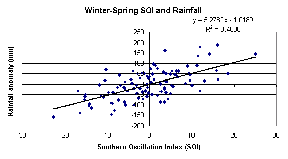 A graph of these two values shows very few periods where one factor moves one way and the other factor moves in the opposite direction. 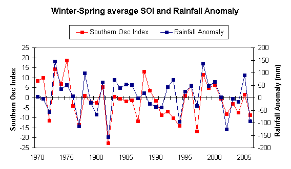 |
||||||||||||||||||||
|
How abnormal is the recent reduction in rainfall ? Not much, and it's easy to see a likely cause. By the way, which period is normal ? Is it the period from 1900-49, 1950-94 or the 10 years to 2004? If you don't know what's normal then how can you tell what's abnormal ? |
||||||||||||||||||||