Arctic Ice
Summary |
|
|
The "equal area" data for Arctic sea ice coverage was
downloaded from website "The Cryosphere Today" and was
examined both as a whole and as 4 equal longitudinal quadrants to
investigate any relationship between ice area and temperature.
The conclusion is that the irregularities in sea ice coverage indicate that any direct relationship to temperature is, at most, only in very general terms. The question of whether sea ice extent is driven by ocean currents, especially those bringing warmer waters to the Arctic, cannot be determined from this data but the lack of any consistent relationship with air temperature, and for that matter with carbon dioxide levels, suggests that warmer waters are a possible cause. |
|
What was done |
|
|
The "equal area" data for sea ice was downloaded
from from the University of Illinois website (see
"The
Cryosphere Today". (For details of the data see
here.) Software was written to
analyse the data and to calculate the sea ice area. These figures vary slightly from that
website because I used the data in the given increments of 10% whereas
"The Cryosphere Today"
uses a minimum cut-off of 15%. (The data contained the
error of repeating November 2000 data for December of that year
but new values have been estimated in accordance with the cycles
of annual sea ice cover.) The equal area data cells were divided into 4 quadrants about the North Pole - which is NOT the centre point of the centre point of the data due to the asymmetrical nature of ice coverage. Data for each quadrant was analysed as well as the total area. The four data quadrants are shown below. (Note that the latitude limit of each quadrant is simply below the maximum extent of the ice.) 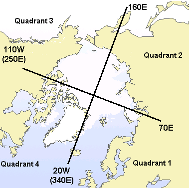 Arctic quadrants |
|
Quadrant 1 (North Atlantic) |
|
The graph below shows monthly
variation of sea ice extent during winter and summer seasons. In
this case the variation in winter is significantly greater than
in summer. 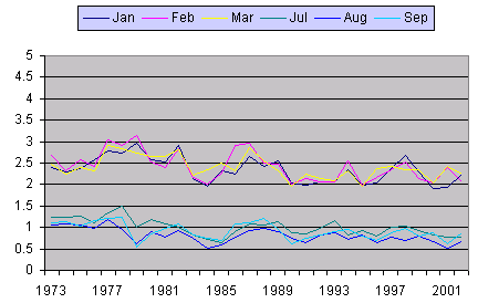 Sea ice extent in each month for the last six years is shown below. From October 1997 to almost October 1998 a severe El Nino existed in the Pacific ocean but there is no clear sign of it in this data for the North Atlantic. 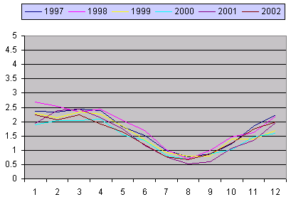 |
|
Quadrant 2 (Kara, Laptev and East Siberian seas) |
|
The graph below shows monthly
variation of sea ice extent during winter and summer seasons.
In contrast to quadrant 1, the variation in summer greater than
in winter. 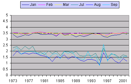 Sea ice extent in each month for the last six years is shown below. The range of variation for each month is less than in quadrant 1during most months and this suggests that the driver is localised rather than global or hemispheric. 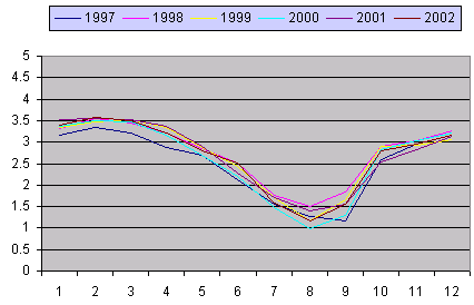 |
|
Quadrant 3 (Chuckchi and Beaufort seas) |
|
The graph below shows monthly
variation of sea ice extent during winter and summer seasons.
Summer variation is not only greater but the decline in summer
sea ice is quite marked and totals about 1.2 million square
kilometres from start to end - and even more between 1976 and
2002. 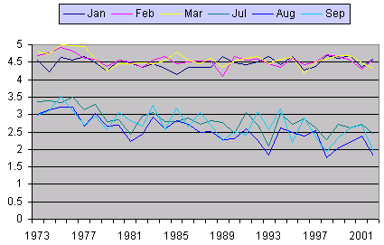 Sea ice extent in each month for the last six years is shown below. Ice coverage in the first 6 months of the year shows far less variance than in the rest of the year and here the extent of sea ice reduced with the El Nino conditions, albeit a few months after the occurrence in the tropical Pacific . 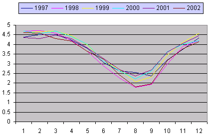 |
|
Quadrant 4 (Canadian Archipelago) |
|
The graph below shows monthly
variation of sea ice extent during winter and summer seasons.
Both seasons show variation but summer more than winter, but
note that the increase in ice area in early 1984 was not
sustained through the middle of the year. 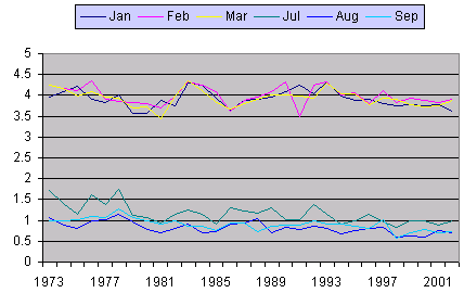 Sea ice extent in each month for the last five years is shown below. In this quadrant the variation between corresponding months of different years is less than Ice coverage in the first 6 months of the year shows far less variance than in the rest of the year. 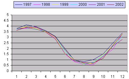 O O |
|
Quadrant Area anomalies |
|
| The extent of sea ice in any month can be expressed as an
anomaly from the long term average for that month. The graph below shows the monthly anomalies for each of the 4 quadrants. The lack of any consistency between the quadrant anomalies suggests that the driving forces are not global. 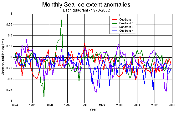 Averaging the above data over 5 months makes the picture clearer although it loses detail. Again the inconsistency of the driving force is quite apparent. Also note that quadrants 1 and 4 show indications of a 5 year cycle but quadrants 2 and 3 shows indications of a much shorter cycle. The principal physical difference is that quadrants 1 and 4 are exposed to the Atlantic Ocean but quadrants 2 and 3 have relatively little exposure to oceans. 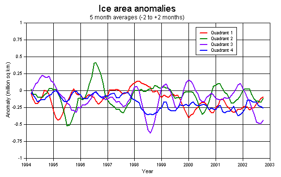 |
|
Putting it all together |
|
The graph below shows the extent of sea ice for each of
the four quadrants. The decrease in sea ice area in quadrants 1
and 3 is greater than in the other two quadrants.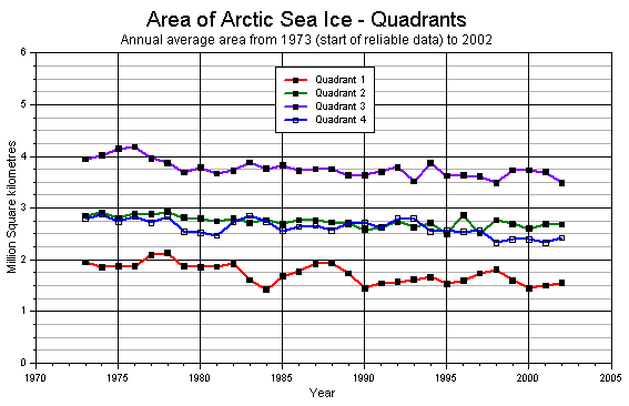 The total Arctic sea ice coverage is shown in the following graph. After five years of general increase the decline was quite abrupt in 1978 and after that the pattern has been irregular and only flattening from the late 1990s. 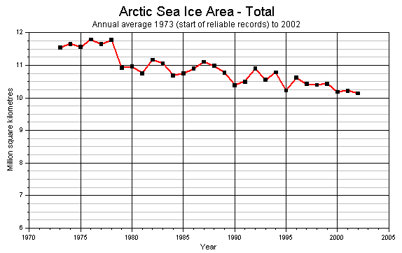 The graph below shows the annual cycle of sea ice extent for 1996-2002. In summer 1997 the sea ice was considerably greater than in summer 2002. 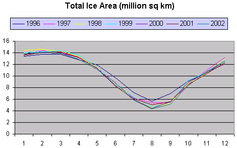 Below is a graph showing the annual average, minimum and maximum extent of ice in the 30 years from 1973 to 2003. The decline in minimum (summer) is greater than the decline in maximum extent (winter) which would be consistent with thinning ice. Note also the inconsistency in the variation; in 1996 maximum sea ice decreased but minimum increased! 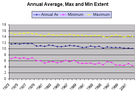 More specifically, the following graph shows sea ice extent for 3 winter months and 3 summer months. The variation in summer is far greater than in winter. 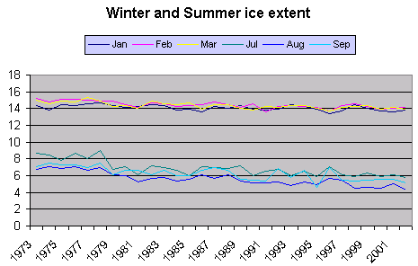 How consistent is the extent of sea ice for the same month in different years? Not very consistent according to the anomalies from the 1973-2002 averages for each month. In September the variation from the average of 6.25 million sq km has been +0.7 million sq km (more than 10%) or -1.2 million sq km (about 20%). 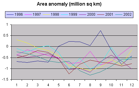 0 0Perhaps the most telling graph is when a proxy for the area free of ice, in this case calculated as (12 - sea ice area), is compared to the global average temperature anomaly. Some degree of correspondence can be seen but equally there are times when the extent of sea ice increases even while temperatures rise or reduce as temperatures decline. There is no clear indication that temperature drove the abrupt decrease in sea ice in 1978. 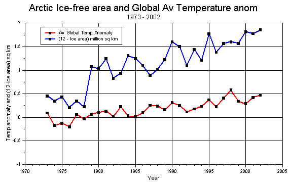 |
|
Final Thought |
|
| Winter sea ice stops short of the Arctic Circle (67N) in the
Norwegian Sea (ie. far North Atlantic) but near Alaska can reach into the Bering Sea and the Sea
of Okhotsk to about 57N. Clearly the difference is that the Atlantic Ocean can move far more heat
northwards than can the Pacific Ocean feeding into the Bering
Strait and the transport of heat by water is a clear likely
explanation for at least some of the reduction in sea ice. |
|